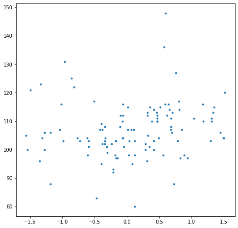
Compare Snow Depths with Interferogram
Goal: Compare the insar phase to snowdepths
Approach: 1. Define an area to study the relationship 2. Grab the snow depths from the magnaprobe in the area 3. Grab the real and imaginary pixels nearest the magna probe locations 4. Plot it
Step 1: Define an Area to Compare Depths to Interferogram
[1]:
from snowexsql.data import PointData, ImageData, SiteData
from snowexsql.db import get_db
from snowexsql.conversions import points_to_geopandas, query_to_geopandas, raster_to_rasterio

from snowexsql.functions import ST_PixelAsPoint
import geoalchemy2.functions as gfunc
from geoalchemy2.types import Raster
from geoalchemy2.shape import to_shape, from_shape
from datetime import date
from sqlalchemy.sql import func
import geopandas as gpd
import numpy as np
from rasterio.plot import show
import matplotlib.pyplot as plt

# PIT Site Identifier
site_id = '5S31'

# Distance around the pit to collect data in meters
buffer_dist = 50

# Connect to the database
db_name = 'db.snowexdata.org/snowex'

engine, session = get_db(db_name, credentials='./credentials.json')

# Grab our pit location by provided site id from the site details table
qry = session.query(SiteData.geom).filter(SiteData.site_id == site_id)
sites = qry.all()

# There can be different dates at a single site, so we only grab one to retrieve the geometry object
point = sites[0][0]

# Create a polygon buffered by our distance centered on the pit
qry = session.query(gfunc.ST_Buffer(point, buffer_dist))
buffered_pit = qry.all()[0][0]
/home/micah/projects/venv/snowexenv/lib/python3.8/site-packages/sqlalchemy/sql/functions.py:61: SAWarning: The GenericFunction 'st_pixelaspoint' is already registered and is going to be overridden.
  util.warn(
/home/micah/projects/venv/snowexenv/lib/python3.8/site-packages/sqlalchemy/sql/functions.py:61: SAWarning: The GenericFunction 'st_pixelaspoints' is already registered and is going to be overridden.
  util.warn(
/home/micah/projects/venv/snowexenv/lib/python3.8/site-packages/sqlalchemy/sql/functions.py:61: SAWarning: The GenericFunction 'st_rastertoworldcoord' is already registered and is going to be overridden.
  util.warn(
/home/micah/projects/venv/snowexenv/lib/python3.8/site-packages/sqlalchemy/sql/functions.py:61: SAWarning: The GenericFunction 'st_clip' is already registered and is going to be overridden.
  util.warn(
/home/micah/projects/venv/snowexenv/lib/python3.8/site-packages/sqlalchemy/sql/functions.py:61: SAWarning: The GenericFunction 'st_count' is already registered and is going to be overridden.
  util.warn(
Step 2: Grab all the Snow Depths in the Area
[2]:
# Grab all the snow depths measured by a probe in the buffer
qry = session.query(PointData).filter(gfunc.ST_Within(PointData.geom, buffered_pit))
points = qry.filter(PointData.instrument.in_(['mesa','magnaprobe','pit ruler'])).all()

# Convert the records received to geopandas
df_points = points_to_geopandas(points)
print('{} Snow Depths found with {}m of {}'.format(len(df_points.index), buffer_dist, site_id))
114 Snow Depths found with 50m of 5S31
Step 3: Grab near polygons of pixels in the area
[5]:
# Loop over all the points
session.rollback()

def custom_query(session, poi, name, polarization, dem):
    '''
    Form a query to grab a value of a raster at a given point with
    filtering on name of the data, uavsar polarization, and the dem used for
    processing.

    Return the records (which should be only one)
    '''
    qry = session.query(ImageData.id,
                  ImageData.type,
                  func.ST_NearestValue(ImageData.raster, poi))
    qry = qry.filter(ImageData.date == date(2020, 2, 12))
    qry = qry.filter(ImageData.type.contains(name))
    qry = qry.filter(ImageData.description.contains(polarization))
    qry = qry.filter(ImageData.description.contains(dem))
    qry = qry.filter(ImageData.site_name == 'Grand Mesa')
    qry = qry.filter(gfunc.ST_Within(poi, func.ST_Envelope(ImageData.raster)))
    return qry.all()
[6]:
df = gpd.GeoDataFrame(columns=['geom','depth','img','real','phase'])

# loop over all our snow depths
for i, row in df_points.iterrows():
    # Form a EWKT geom object to find values
    poi = from_shape(row['geom'], srid=26912).ST_AsEWKT()

    # Grab the nearest pixel value to our snow depth
    img = custom_query(session, poi, 'interferogram imaginary', 'VV','DTM')
    real = custom_query(session, poi, 'interferogram real', 'VV','DTM')

    # Store for later
    results = {'img':img[-1][-1],
               'real':real[-1][-1],
               'geom': row['geom'],
               'depth':row['value']}

    # Add it to our df
    df = df.append(results, ignore_index=True)


# Close the session to avoid hanging transactions
session.close()
[7]:
# Calculate the phase
df['phase'] = np.arctan(df['img'] / df['real'])
[8]:
fig, ax = plt.subplots(1,1,figsize=(8,8))

# Plot the comparison
ax.plot(df['phase'], df['depth'], '.')

plt.show()